 |
||||
 |
||||
 |
||||||||
Nice walk, but how do I get there? Well you should go to the Tregare Street meeting point, be early we leave promptly.That way you can car share with others. But if you need instructions to get to the walk start point this page may be where you can find them. A map reference, latitude and longitude for your sat. nav., a link to a map, or someone's helpful instructions. I’ve tried to make these directions correct. Apologies if they are not. All feedback will be welcome. Also if you follow the links to a map, you can zoom in or out, and change the map style to whichever you find easiest to read. |
||||||||
 |
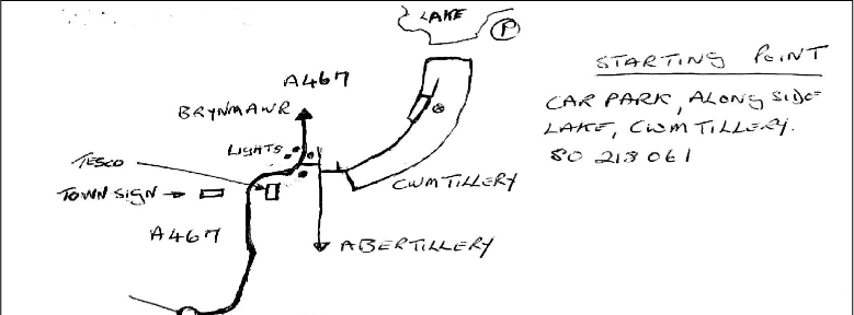
Cwmtillery Lakes ( Car park alongside lake Cwmtillery) Map Ref.SO218061 Nearest Postcode NP13 1LS Latitude N51°44' 54.135" (51.748371) Longitude W -3° 8' 2.5656" (-3.134046) what3words prefer.bought.divisible Suggested Route M4 to High Cross (J 27) Proceed on Risca Road B4591 to roundabout. Turn left down Chartist Drive to join A467 (Signed Brynmawr) Continue on A467 to Abertillery. On passing blue town sign, take the next turning right by the lights ( signed Town Centre) Turn left & follow Cwmtillery signs & brown tourist lake signs. |
|||||||