 |
||||
 |
||||
 |
||||||||
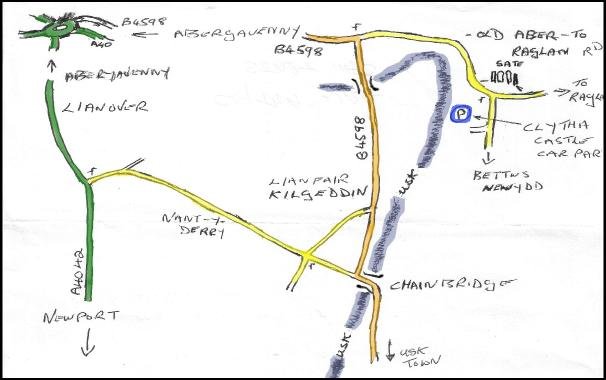
Nice walk, but how do I get there? Well you should go to the Tregare Street meeting point, be early we leave promptly.That way you can car share with others. But if you need instructions to get to the walk start point this page may be where you can find them. A map reference, latitude and longitude for your sat. nav., a link to a map, or someone's helpful instructions. I’ve tried to make these directions correct. Apologies if they are not. All feedback will be welcome. Also if you follow the links to a map, you can zoom in or out, and change the map style to whichever you find easiest to read. |
||||||||
Clytha Folly Map Ref. SO361085 Nearest Post Code NP7 9BW Lat N51°46' 19" (51.771965) Long W2°55' 36" (-2.926762) Suggested Route Take the Newport to Abergavenny road (A4042). Just before Llanover turn right on to the minor road signed Nant-Y-Derry & Chainbridge. Follow this road around, passing through Nant-Y-Derry until a crossroads is met. Turn left here on minor road signed Clytha & Raglan. Turn left when this minor road joins the B4598. Continue ahead passing through Llanfair Kilgeddin & over the River Usk. On meeting a T junction, turn right, (Old Abergavenny to Raglan Road.) Continue ahead until a right turn is reached, signed Bettws Newydd Golf Course. (Opposite Clytha Park main gates.) Down this road for a short distance & then turn right into the car Park. |
||||||||